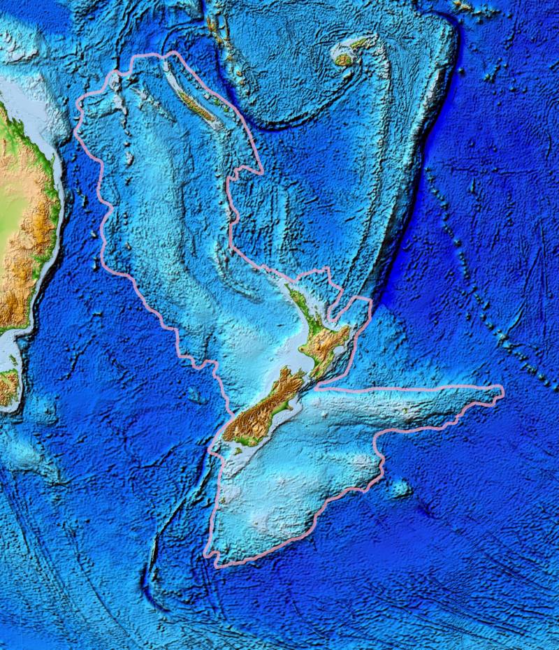
The legend of Atlantis has captivated imaginations worldwide, yet it remains a myth. However, submerged landmasses do exist, with Zealandia, a hidden continent beneath New Zealand, being one of the most intriguing examples.
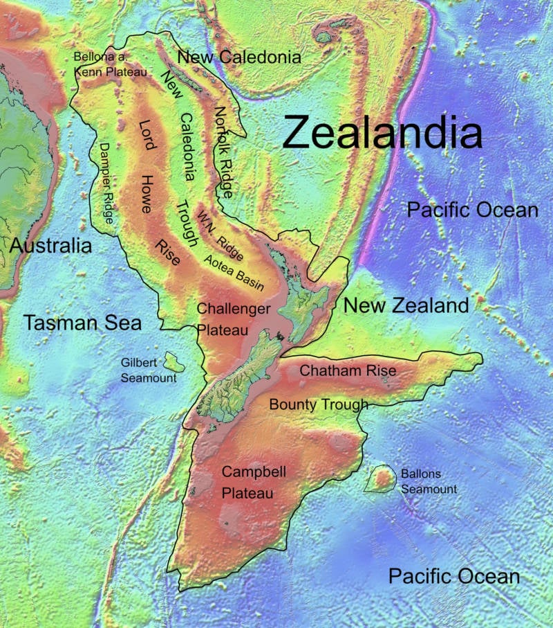
Zealandia, which covers nearly two million square miles, is mostly underwater and has always captured the curiosity of scientists. Research into this submerged continent could provide valuable insights into the seafloor's composition, historical climate changes, and even pollution. Additionally, understanding Zealandia could have significant economic benefits for New Zealand.
Recently, researchers from the University of Queensland have begun mapping the boundaries of Zealandia, offering a new and detailed look at this submerged world.
The First Discovery Of Zealandia
Though largely underwater, Zealandia exists as a real, submerged continent in the Pacific Ocean. It is not uninhabited.
This is because about six percent of Zealandia remains above water, forming New Zealand and several surrounding islands. These lands represent the highest points of what was once a vastly larger terrestrial area.

Therefore, Zealandia wasn't so much discovered as it was formally acknowledged.
In 1995, Zealandia came to the attention of Bruce Luyendyk, an American geophysicist and oceanographer. While studying Gondwana—a segment of the ancient supercontinent Pangaea that split around 180 million years ago to form today's continents of South America, Africa, India, Australia, and Antarctica—Luyendyk stumbled upon Zealandia.
Luyendyk's exploration of this region dates back to the 1980s when he endeavored to correlate the geological features of Antarctica with those of New Zealand, a task comparable to reassembling a fragmented puzzle.
This investigative effort led Luyendyk and his team to scrutinize the seabed surrounding New Zealand more closely. To their surprise, they discovered that the rocks beneath the nation could potentially qualify as a separate continent.
What Makes A Continent?

Most school curricula teach that there are seven continents. However, some geologists contend that there are only six, arguing that Europe and Asia should be considered a single continent.
The classification of Zealandia as either the seventh or eighth continent has been a subject of debate among geologists. They maintain that Zealandia deserves to be recognized as a continent in its own right.
Geologists support their claim by pointing out that the rock beneath New Zealand meets the established criteria for continental classification, based on Luyendyk's findings. Naming the region Zealandia, Luyendyk highlighted that New Zealand and its surrounding islands are not isolated but part of a larger submerged entity. This sparked further research, affirming that Zealandia shares essential characteristics with other continents, despite being largely underwater.
Moreover, Zealandia is elevated above the ocean floor, distinguishing it from the surrounding seabed not only in elevation but also in composition. Unlike the denser oceanic crust, Zealandia consists of the lighter, less dense material typical of continental crust.
Zealandia's composition aligns with that of recognized continents, featuring all three primary rock types: igneous, metamorphic, and sedimentary. These rocks indicate that Zealandia underwent volcanic activity, heating, pressure, and erosion processes similar to other continents.
Zealandia's size also supports its classification as a continent rather than a mere continental fragment. While some have suggested labeling it a "microcontinent," others have countered this by highlighting that Zealandia's rock extent is much larger than that of any known microcontinent.
The debate over whether Zealandia should be considered a continent might seem purely academic, but it has significant practical implications.
The classification of Zealandia impacts economic rights, particularly concerning offshore drilling. The United Nations uses continental boundaries to determine a country's rights to marine resources. If Zealandia is recognized as part of New Zealand's continental shelf, it could greatly enhance the nation's economic prospects.
According to some estimates, recognizing Zealandia as a continent could unlock access to fossil fuels worth tens of billions of dollars for the country.
In 2017, the debate was resolved when Zealandia was officially recognized as the eighth continent of Earth.
Piecing Together Zealandia's History
A key role in affirming Zealandia's continental status was played by an expedition that drilled into its submerged rock layers in 2017.
The undertaking was challenging due to the continent's location beneath two-thirds of a mile of ocean water. To collect a variety of samples, the team drilled down 4,000 feet into the sediment, a process that spanned nine weeks.
The expedition's findings were significant. Geologists now believe that Zealandia separated from Antarctica between 85 and 130 million years ago and later detached from Australia between 60 and 85 million years ago.
This research supports the theory and suggests that as Zealandia separated from Australia, its crust stretched and thinned, causing it to sink to the ocean floor.
While no human has ever seen the continent above water, researchers have unearthed hundreds of fossils, crushed shells, and pollen samples indicating that Zealandia was once at a much shallower depth than previously believed.
Consequently, there was a period when animals could easily traverse between the continent's highest points and tropical plants flourished atop its peaks.

This discovery is a crucial component of several broader scientific inquiries.
Particularly, uncovering that the region once had a tropical climate provides new climate data, helping scientists not only understand historical weather patterns but also improve predictions of future climate changes.
This discovery sheds light on longstanding queries regarding the evolution and dispersion of the region's fauna across continents. It reveals a new image of Zealandia as a lush, vibrant jungle bustling with life — now submerged beneath the ocean.
Mapping A 'Hidden' Continent
Since the formal recognition of Zealandia as a continent in 2017, scientists have embarked on the challenging task of delineating its boundaries, complicated by the fact that much of it lies underwater.
"We're only just starting to discover Zealandia's secrets," said Dr. Derya Gurer, an earth scientist with the University of Queensland. "It's remained hidden in plain sight until recently and is notoriously difficult to study."

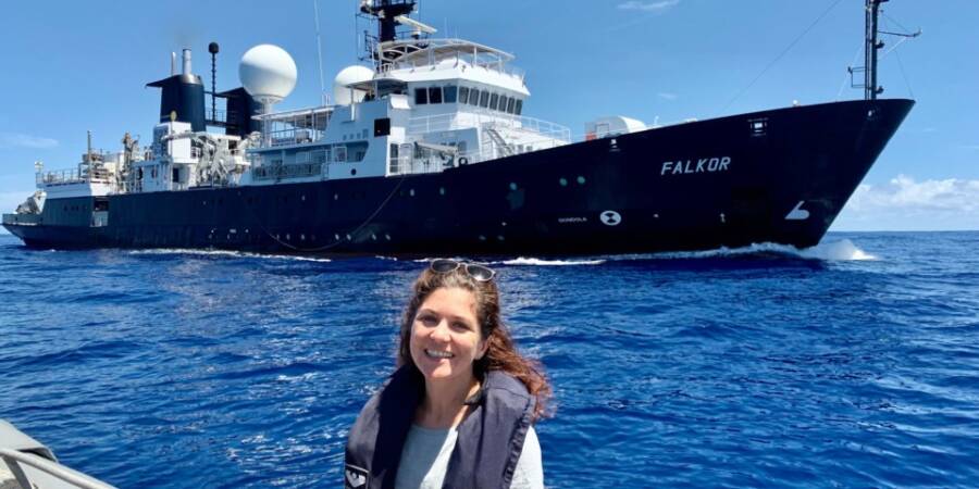
To accomplish this, the University of Queensland has collaborated with the Schmidt Ocean Institute. Leading the effort, Chief Scientist Gürer and his team spent 28 days surveying 14,285 square miles of Zealandia's northwestern region.
"Our expedition collected seafloor topographic and magnetic data to gain a better understanding of how the narrow connection between the Tasman and Coral Seas in the Cato Trough region — the narrow corridor between Australia and Zealandia — was formed," Gürer explained.
Beyond its primary objective, the expedition to map Zealandia also contributed to broader scientific initiatives. It provided 14,000 square miles of data to the Seabed 2030 project, which aims to map the ocean's depth comprehensively by 2030. To date, less than 10 percent of the seafloor has been mapped.
Additionally, as the research vessel Falkor navigated the waters, it not only collected seawater samples but also gathered plastic debris. Out of over 100 samples collected, only one was free of visible microplastics, highlighting a troubling prevalence of pollution that poses risks to marine life.
"It wasn't a huge surprise that we found microplastics given their prevalence globally, but it was still quite shocking how much we found," Gürer said.
Scientists face a monumental task ahead. Zealandia covers nearly two million square miles, yet the latest mapping effort has only covered 14,000 square miles of this vast submerged continent.
"The seafloor is full of clues for understanding the complex geologic history of both the Australian and Zealandian continental plates," Gürer continued.
As researchers like her continue to explore the ancient seabed, there is growing excitement about the secrets Zealandia might unveil about the Earth's geological and ecological history.


